This was a navigation flight along the CTR of Liege (EBLG). We also talked to some air traffic controllers.
Flight Facts
Date: 20 aug 2020, 08:30 (UTC)
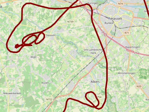
Route: EBZH - NOVEM (Tongeren) - ROMEO (Waremme) - EBAV - EBZH
METAR:
- METAR EBBL 200625Z 21007KT 9999 BKN040 22/18 Q1007 BLU BLU=
- METAR EBLG 200520Z 21010KT 9999 FEW035 20/17 Q1008 TEMPO
Type: Navigation
Flight time: 01:13
GPS Track
Running Costs
01:13 flying time: € 79,90
01:13 hour instructor time: € 45
Flight Description
This navigation flight was part of the preparation for my practical exam.
Additionally, we also practiced radio communication a bit by talking to the TOWER of Liege and the APPROACH of Beauvechin (military).
Liege to inform them we'd be near their CTR flying from Tongeren (NOVEM) to Waremme (ROMEO). Beauvechin to ask them to enter D37, a zone that is active during military operating hours, but we wanted to fly over EBAV (and land if they were open).
EBAV wasn't open, sadly.
The radio conversation was a little messy. Liege Tower didn't really catch our immatriculation, calling us "One Two Three". But he was very friendly because he immediatly invited us to enter the CTR, even though that wasn't our plan. Beauvechin was a little more relaxed, since they weren't busy at the time. They identified us, cleared us for the D37 and then approved our Frequency change back to Hannut Radio (Avernas).
Forced Landings
On our way back, direct from EBAV to EBZH via Sint-Truiden (EBST), my instructor let me do two "Practice Forced Landings". This goes as follows:
- The instructor pulls the throttle to Idle, to simulate engine failure - at this point you are effectively a glider
- First pull the nose up a bit to covert excess airspeed into altitude
- Secondly, check if both fuel taps are opened
- Find a suitable field to land, preferably up-wind
- When reaching 100 km/h (this aircraft type) set flaps to T/O for optimal gliding distance
- Fly to the field, circle over it to inspect the environment on and around the field (tractors, fences, trees, electricity wires, ...)
- Identify points for the base and final turns
- When at around 900 ft, fly away from the field to the base turn
- Turn final
- If too high, set full flaps, slip if necessary
- When it's clear a landing would be succesful, full throttle, nose on horizon, flaps T/O and climb away
I'd love to see this from the ground once!
My instructor makes much steeper turns though, allowing inspection of the field through the side window - no problem as long as you keep an eye on the airspeed.
Next Flight
We agreed on doing some solo circuits next.