We planned a navigation, from Hasselt (home base) over Liernu, land in Goetsenhoven (EBTN) and then back to Hasselt.
First of all, still failed to remember to take pictures.
Flight Perparation
I was on the airfield ahead of time this time! But we lost the time again. We needed some gas, but I couldn't get the plane to the station because of another parked plane, so we had to wait a bit.
Then we had some problems with the gas pump, so we had to take another one.
Anyway, it took a while.
According to my GPS track, we were eventually airborne at 10:55 (local time).
The flight I planned, exclusive landing, was about 35 minutes flying at 100 kts. Of course, we also have to count taxi time and landing circuit time.
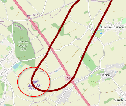
What I actually missed, was that Liernu has a small ULM airfield! I had planned to turn around back to EBTN just before the highway and windmills, but I had to pass over them. So that would've added some time.
Eventually, we decided on fueling for at least two hours. We use about 20 liter per hour, so we had to have at least 40 liter. Each tank is about 45 liter so filling each tank half would be enough. We filled it a little more.
Navigation
I had planned my flight on the map, and had some waypoints:
- 210° from Hasselt to Sint-Truiden: a slightly big city easy to spot, I'll pass between the city and the military airfield (EBST)
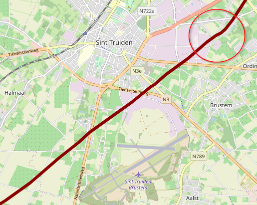
- 230° from Sint-Truiden to Avernas aerodrom (EBAV): it's located just after passing a highway surrounded by a number of windmills
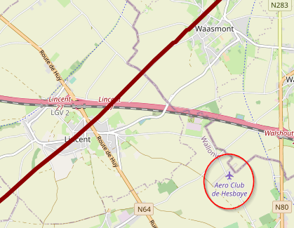
- 230° from Avernas to Liernu (EBLN): identified in a similar way to EBAV, it's the next highway surrounded by a group of windmills. The airfield itself is just next to a forrest
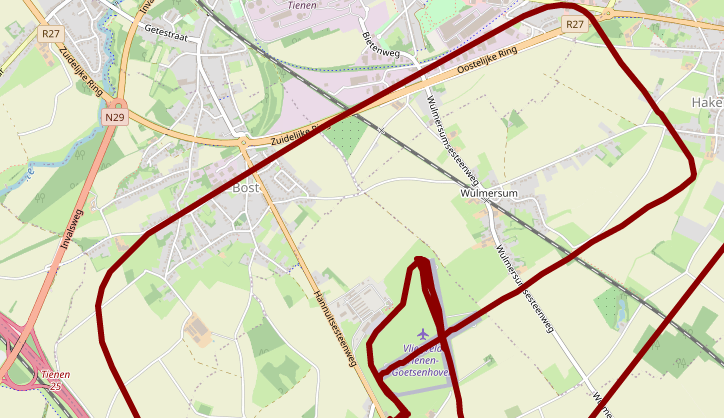
- 030° from Liernu to Goetsenhoven (EBTN): identified mostly by the city of Tienen, which has some industry and is easy to spot. It's not a super small airfield, with two asphalt runways, but it's a lot harder to spot an airfield than I thought. Especially between other fields.
- 050° from EBTN back to EBZH: identified by the city of Hasselt and easy for me to find by now, since we fly there all the time
Landmarks
A lesson I learned, while flying and my instructor asking me "what is that city, where are we now, what will we see on the route" is that I should've put more work in identifying important spots along the route.
Especially on the way back from Goetsenhoven to Hasselt, I didn't put down any waypoints. Although I was able to spot my house on the way back!
For example, my route took me passed the city of Landen, which is a city that is easy to spot and also has a railroad running through it. It also has a train station close to which is a very easy to spot water tower:

The following things are useful as landmarks:
- Reasonably sized cities
- Railways
- Rivers, channels, bridges
- Highways (preferably in line with the route, if they are perpendicular it's more difficult)
- Significant buildings
- Forrests with a distinct shape (shown on the map)
- Airfields
- A group of windmills
Best is to have a landmark and some additional properties. For example Landen is a city, but it is also a city with a distinct railway station.
EBLN is an airfield, but it is located near a highway, some windmills and disntinct forrest.
Weather
METAR EBBL 271025Z AUTO 22014KT 9999 BKN029/// 25/16 Q1009 BLU=The weather was good but there was a strong southern wind, that actually picked up while we were flying. The air was quite unstable, which made it great for gliding - but that's not what we're doing!
Because of the strong head wind, it took us a while to get where we needed to be. To illustrate, we had an IAS (Indicated Airspeed) of 160 km/h (yes the indication is in km/h and not kts) but our ground speed was a little under 120 km/h.
On the way back, we had tail-wind, so that went a lot faster with a ground-speed over 200 km/h.
Fly-over EBLN
At Liernu we located the airfield and did a fly-over. A fly-over in a way that allowed me to spot the signal square. It indicated the airfield was closed: red triangle with a yellow diagonal cross.
Landing at EBTN
I only landed on another airfield once before. We came into the circuit nicely, my instructor handled the radio. But on our down-wind turn we noticed we were still quite high.
For some reason, the runway that was open was 24, which is strange with the strong wind from the south. We had a strong cross-wind.
Because we were too high, my instructor told me to to slip a little.
Coming down, I was rounding off too late. The mistake I made was the following:
- It was an asphalt runway and I was really focused on landing in the center of the runway
- I wasn't looking at the end of the runway!
I really want to do that again, because it wasn't a great landing.
Take-off at EBTN
We were taxi-ing to runway 24 for take-off. To get to the holding point, we had to taxi a little bit on runway 17. While we were ON the runway, they announced on the radio they'd switch from runway 24 to 17. I actually didn't hear that on the radio! But my instructor did, we then turned around and back-tracked on the runway to the holding point.
We then took off and flew back to Hasselt.
The landing in EBZH was also tricky, because also there we had the strong cross-wind. A cross-wind from the South in Hasselt is especially annoying because trees and buildings cause some turbulence.
My instructor advised me, after a difficult landing:
- The more unstable the air is, the more relaxed you have to be
- Steer the plane in the general direction and let the plane do it's quircks and don't overcompensate
Radio Communication
One small lesson about communication: I kept forgetting to express headings correctly: not "fifty degrees" and "two hundred thirty degrees" but "zero five zero degrees" and "two three zero degrees".
METAR
METAR EBBL 271025Z AUTO 22014KT 9999 BKN029/// 25/16 Q1009 BLU=GPS Track
Running Costs
1:18 flying time: € 132,60
1:30 instructor time: € 54,00
Landing fee EBTN: € 5,00